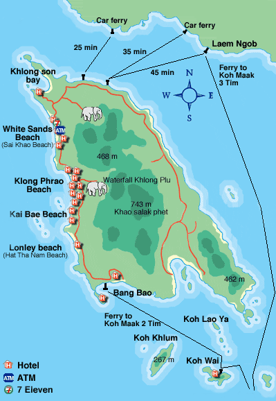
Map of Koh Chang

 Trat is sandwiched by mountain ranges to the east and coastlines to the west with well-preserved natural beauty. It is blessed with 52 islands which scatter like jewels along the Gulf of Thailand. Bangkok lies 315 km to the northwest and Trat itself covers an area of 2,819 sq km. It contains 5 districts--Muang, Khao Saming, Laem Ngob, Klong Yai and Bo Rai-- with the addition of 2 sub-districts, Koh Chang and Koh Kood.
Koh Chang, often called the Elephant Island because its shape on the map looks like an elephant head. is Trat's largest island, is the second largest in Thailand, behind Phuket. The island is about 30 km long and almost 14 km wide. The interior of the island is mountainous and covered with tropical rainforest, with the highest elevation being Khao Salakphet, at 743 metres above sea level.
In 1982, the island and its 51 surrounding small islands came under protection as part of the Koh Chang Marine National Park. About 85% of the island is given the national park designation, which is mostly rainforest found inside the island. Animals in the park include the stump-tailed macaque, the small Indian civet, the Javanese mongoose and around 61 resident bird species. The Koh Chang wart frog is native to the islands and the mainland of Trat as well.
The Mu Ko Chang National Park - National Marine Park comprising parts of Ko Chang and 46 other islands
War memorial monument - in the very south of the island

Waterfalls
Klong Plu - the most popular, and the only one on the west side of the island
Klong Nonsi - on the east side of the island
Klong Nueng - said to be the most breathtaking
Khiri Petch - medium sized, about 3 kilometers from Salak Petch village
Kongoi - 5 waterfalls near Bangbao
The Thanmayom - near Thanmayom pier
Package tours for snorkeling, diving, elephant riding etc. are widely available.
Thaifun day cruise to southern islands. Relaxing and snorkeling. Very nice crew on board.
Khlong Plu waterfalls is medium size waterfall within a half a mile walk from parking area. Swimming possibility. Entrance fee to park 400 baht.
Ploy Scuba Diving come to the best dive sites with speedboat. All PADI Course / Diving Trips / Snorkelign Trips. ploy.travel@gmail.com
Snorkeling and Diving Koh Chang is maybe not the best diving spot in Thailand, but diving around Koh Chang gives some adventurous feeling
See Fireflies Boat trips on the lagoon near Khlong Prao beach to see fireflies can be organised through a travel agent/hotel. Year round. 150-200 baht for 30 minute trip.
Koh Chang has three seasons. The cool season is from November to February, the hot season from March to June and the rainy season from July until October. The best travel time is from November to February, it is not too hot then. Nevertheless naturally also the remaining months have their attraction.
Existing weather in Chanthaburi, Thailand

Click here for 5 day forecast of Koh Chang weather
Precipitation降水資料
Based on Klong Phrao Beach. Values in mm (= litre per m2)
| |
2004 |
2005 |
2006 |
2007 |
| Jan |
-- |
52 |
0 |
43 |
| Feb |
-- |
18 |
135 |
13 |
| Mar |
-- |
127 |
60 |
27 |
| Apr |
-- |
133 |
155 |
143 |
| May |
267 |
310 |
430 |
536 |
| Jun |
561 |
547 |
442 |
334 |
| Jul |
660 |
450 |
851 |
797 |
| Aug |
466 |
189 |
348 |
255 |
| Sep |
424 |
407 |
1027 |
661 |
| Oct |
305 |
249 |
586 |
142 |
| Nov |
14 |
81 |
11 |
110 |
| Dec |
0 |
36 |
11 |
0 |
| Total |
2697 |
2599 |
4056 |
3069 |